Nine must-visit Maya ruins in Belize — which to choose depends on your time, mobility, and what you want to learn or photograph. If you’re deciding where to start, the full Caracol guide is the most detailed site deep-dive on this site and a good next read for the largest pyramids and inscriptions.

| Trip Length | Best picks & access |
| Day trip / cruise stop | Altun Ha, Lamanai (boat), Cahal Pech — easy access from Belize City or San Ignacio. |
| Multi-day / archaeology focus | Caracol (rough road, full-day), Xunantunich, Uxbenka — bring a guide; see the full Caracol guide for logistics. |
Why Belize For Maya Ruins
Belize contains one of Central America’s densest concentrations of Maya sites — more than 1,400 recorded locations spanning millennia. Its rivers, coastal access and interior highlands produced a network of trade, agriculture and astronomy-driven architecture that you can still read in plazas, pyramids and stelae.
The Nine Must-Visit Ruins (At-A-Glance)
Below are compact visit notes and what makes each site different. For site-level logistics and longer histories, follow the contextual links to deeper pages throughout this article.
Lamanai — River Approach, Long Occupation
Accessible by boat on the New River Lagoon, Lamanai’s Mask Temple and Jaguar Temple rise from jungle canopy. The boat trip itself gives context to the site’s role as a riverine trade center.
Altun Ha — Jade Head And Easy Access
Near Belize City, Altun Ha is a compact, visitor-friendly site where the famous carved jade head was discovered. Good for short itineraries and cruise passengers.
Santa Rita & Cerros — Late-Contact Archaeology
Northern sites that show continuity into the colonial period and strong ties to maritime trade networks.

Xunantunich — Blufftop Pyramid And Ferry Crossing
A short ferry from San Ignacio leads to El Castillo with an astronomical frieze; family‑friendly but rewarding for archaeology-minded visitors. Read more about visiting the Cayo region in our Cayo district guide.
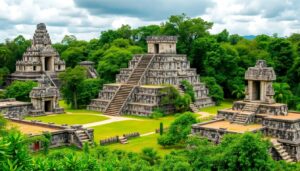
Caracol — Belize’s Largest Site (Teaser)
Caracol’s Caana temple and extensive stelae make it the most archaeologically significant and logistically demanding site on this list; roads can be rough and a full-day visit is normal. For the complete on-site logistics, history and maps see the site deep-dive in our full Caracol guide.
Cahal Pech — Early Civic Center, Near Town
Ideal for a gentle introduction to Maya architecture, Cahal Pech sits just above San Ignacio and is an easy half-day or morning visit.
Lubaantun — Mortarless Masonry In The South
Unique black-slate construction and quiet hilltop setting in Toledo make Lubaantun a specialist visit for architecture fans.
Nim Li Punit & Uxbenka — Carved Stelae And Astronomical Alignments
Both southern sites feature carved monuments and alignments; Nim Li Punit’s tall stelae are photogenic and approachable, while Uxbenka offers recent excavation insights into solstice alignments.
When To Go & Booking Window
| Best Season | Dry season (Nov–Apr) for clear skies and easier roads; shoulder months (May, Oct) reduce crowds but expect showers. |
| When To Book | For peak season, book guides and transport 6–8 weeks ahead; for day trips, 1–2 weeks is usually sufficient. |
Planning Checklist: How To Visit
- Transport: Caracol needs a 4×4 and a full day; many northern sites are reachable by boat or paved roads.
- Fees & guides: Expect official entrance fees; licensed guides add archaeological context and support conservation.
- Packing: sun hat, reef-safe sunscreen, insect protection, sturdy shoes, water and snacks, and a lightweight rain shell.
- Respect: don’t climb fragile structures, avoid flash in mural chambers, and follow local guide instructions.
1-Day (From Belize City) Altun Ha in the morning; transfer back via Belize City highlights or short museum visit.
3-Day (Cayo Base) Day 1: Xunantunich + San Ignacio town; Day 2: full-day Caracol (see the Caracol guide); Day 3: Cahal Pech and local markets.
Family-Friendly Option For families with children, our family Maya ruins guide highlights shorter walks and safer sites.
Conservation, Community And Context
Belize’s Institute of Archaeology manages reserves and uses entrance fees to fund preservation. Community‑based tourism channels income to local Maya communities, especially in Toledo where traditional milpa agroforestry still sustains cultural continuity. Follow guide rules and local signage to help protect fragile limestone and carved surfaces.
Where To Read Next (Site Deep-Dives)
For full logistics, maps and excavation history: our detailed Caracol guide and the Cayo district guide will help you plan an extended ruins-focused trip. Families should consult our family ruins guide for suitable sites and activities.
Frequently Asked Questions
It depends on your goal: Caracol for scale and inscriptions; Lamanai for the river approach and long occupation; Altun Ha for quick access and iconic finds.
Over 1,400 recorded sites exist, but 14 are managed as official archaeological reserves by Belize’s Institute of Archaeology.
Yes—Belize’s sites offer accessible archaeology, varied architectural styles, and living cultural connections; a single visit can add historical context that complements reef or rainforest activities.
Start with the Caracol deep-dive for logistics on Belize’s largest ancient city, or pick a family‑friendly route in our kids guide linked above.
Sophie Daniels is an accomplished travel writer and expert on Belize, dedicated to sharing the beauty and culture of this Central American gem. With a passion for adventure and a deep understanding of the local landscape, she crafts insightful and engaging guides that inspire travelers to explore Belize’s vibrant ecosystems and rich heritage. Through her writing, Sophie aims to connect readers with the heart of Belize, offering practical tips and personal anecdotes that enhance their travel experiences.

Your exploration of Belize as the heart of the ancient Maya civilization prompts a deeper reflection on how the remnants of this culture inform our understanding of historical adaptability and resilience. The staggering number of sites, over 1,400, certainly underscores a rich tapestry of history waiting to be unraveled. However, it also raises questions about what leads to the rise and fall of such civilizations—particularly in relation to environmental factors, trade practices, and sociopolitical decisions.
Your exploration of Belize as a cradle of ancient Maya civilization highlights the profound connection between geography and cultural development. It’s fascinating how the fertile river valleys and access to marine resources not only fostered agricultural abundance but also facilitated complex trade networks that were essential for the emergence of such a sophisticated society. This synergy between environment and societal evolution is a theme that resonates throughout various civilizations globally.
You’ve touched on a really intriguing point! The interplay between geography and the cultural development of the ancient Maya is a captivating subject. It’s interesting to think about how their environment – like those lush river valleys – was not just a backdrop for their existence but a key player in shaping their society. The Maya didn’t just settle in fertile areas; they mastered their landscapes. They engineered terraces and irrigation systems, transforming often challenging environments into thriving agricultural hubs. This ingenuity allowed them to support large urban centers.
“To dive deeper into the remarkable interplay between geography and civilization, check out this insightful resource!”
https://xamanekbelize.com/cultural-tours
Your exploration of Belize as the heart of the ancient Maya world is fascinating, particularly in how it highlights the interconnectedness of their civilization with the natural environment. It makes me reflect on how the geographical advantages—like abundant waterways and coastal access—were not merely beneficial for survival, but essential for cultivating the sophisticated political and trade networks that sustained such a long-lasting civilization.
Your exploration of Belize’s ancient Maya sites highlights not only the remarkable achievements of this civilization but also the profound connections we can draw between its historical context and contemporary issues. The Maya civilization, with its intricate societal structures and advancements in agriculture, astronomy, and writing, presents a fascinating case study of human innovation and resilience.
I’m really fascinated by how intertwined the Maya civilization was with its environment, especially considering the fertile river valleys you mentioned. It’s amazing to think that such a complex society thrived in harmony with nature and utilized their resources so effectively for trade and agriculture.
Ah, the ancient Maya—really puts my living room décor to shame, right? I mean, here I am struggling to figure out whether that new throw pillow matches my couch, while the Maya were crafting pyramids and setting up temples like they were IKEA furniture—totally knew how to nail that “open floor plan” look!
Your exploration of Belize’s rich Maya heritage certainly highlights the significance of this region beyond just its archaeological marvels. As you’ve pointed out, the Maya civilization thrived due to a unique confluence of natural resources and sociopolitical structures. This brings to mind the broader implications of the Maya’s environmental adaptability and sustainable practices, which modern societies could learn from today.
Ah, Belize—the gift that keeps on giving! With over 1,400 ancient sites, it’s like a treasure map where X marks… well, a whole lot of Xs! I always find it fascinating how the Maya managed to thrive with such savvy trade routes. You gotta wonder if they held the first “Ancient Maya Networking Event”—who knew pyramids would be the original skyscrapers of the region!
Your exploration of Belize’s rich Maya heritage is fascinating and truly highlights the intricate tapestry of history embedded in this vibrant country. I’ve always been captivated by how ancient civilizations adapted their lives to the natural world around them. The Maya’s deep understanding of their environment, from the fertile river valleys to the access provided by the second-largest barrier reef, speaks volumes about their ingenuity and resourcefulness.
I really enjoyed reading your insights on the ancient Maya sites in Belize! It’s fascinating how this region was a thriving hub of culture and trade thousands of years ago. The complexity of their society always amazes me, particularly how they managed resources from both the fertile land and the sea.
Your exploration of Belize as the heart of the ancient Maya world certainly invites a richer understanding of this remarkable civilization. It’s fascinating to think about how its core elements—fertile lands, coastal access, and intricate trade networks—contributed to such an advanced society. I find it particularly intriguing when considering the juxtaposition of the Maya’s flourishing culture with the significant societal changes imposed during the colonial period. The archaeological remnants we see today not only tell us about their innovations in agriculture, architecture, and astronomy but also evoke a complex narrative about resilience and adaptation in the face of colonization.
The sheer number of ancient Maya sites in Belize is indeed impressive, but it also raises questions about how we engage with these historical treasures. For me, the real intrigue lies in understanding how the Maya’s advanced agricultural practices and political structures allowed them to thrive in such a challenging landscape. It’s fascinating to think about how those same river valleys that once supported a complex civilization are now crucial for modern Belizean society.
I’ve always found the Maya civilization to be incredibly fascinating, especially during my travels to Central America. The sheer number of ancient sites in Belize is mind-boggling! It’s interesting to consider how the geographical advantages you mentioned—like the fertile river valleys and coastal access—played such a crucial role in shaping Maya society.
It’s great to hear how much you’ve enjoyed exploring Central America. The sheer beauty and complexity of the Maya sites in Belize really does leave an impression. Those fertile valleys not only supported agriculture but also fostered a rich cultural landscape where art, science, and governance thrived. It’s fascinating how the geography shaped their daily lives and rituals, allowing them to build such intricate societies.
Reading about Belize’s ancient Maya sites really brings to life the rich tapestry of history embedded within that region. I’ve always been fascinated by how civilizations like the Maya adapted to their environments and built complex societies without the technologies we often take for granted today. The varied landscapes of Belize—the lush river valleys and coastal areas—must have provided an incredible array of resources that influenced their agricultural and trade systems.
Oh, the ancient Maya! As if time-traveling back to a civilization that prospered long before we decided that wearing pants was essential for civilization! Who knew Belize was essentially a Mesoamerican hotspot, with ancient cities popping up like they were preparing for an archaeological convention? I mean, over 1,400 sites? That’s more than enough for a week-long road trip through history.
Your exploration of Belize as the heart of the Ancient Maya world brings to light the incredible depth of this civilization’s achievements and its significance in the broader context of Mesoamerican history. Having visited some of these sites myself, I can attest to the awe they inspire. There’s something rather captivating about standing in the shadow of Lamanai’s temples, where the sounds of the river and dense surrounding jungle create an atmosphere that feels almost alive with the echoes of history.
Your exploration of Belize’s rich archaeological landscape vividly brings to life the importance of the ancient Maya civilization. The intricacies of their societal structures and their reliance on both agriculture and trade underscore how civilizations can thrive through strategic resource management and social cohesion.
It’s fascinating how the Maya civilization was able to thrive in such diverse environments and establish a complex social structure. I visited some of the ruins a couple of years ago, and it genuinely took my breath away to stand amidst the towering pyramids and imagine the life that once flourished there.
Your exploration of Belize and its ancient Maya sites highlights an incredible aspect of the region’s historical significance that often goes overlooked. I appreciate how you emphasize the diversity of the sites, such as the distinct architectural styles found in Lamanai and Caracol. It’s fascinating to consider how these ancient structures reflect the sociopolitical complexities of Maya civilization, including their trade networks and religious beliefs.
I find it fascinating how the ancient Maya civilization thrived in such a diverse environment! The connection between geography and the cultural practices of the Maya truly highlights the sophistication of their society. It’s intriguing to think about how the fertile river valleys of Belize not only supported agriculture but also shaped political alliances and trade dynamics throughout the region.
It’s great to hear your thoughts on the ancient Maya civilization. You’re right; their relationship with the landscape was intricate and influential. The fertile river valleys you mentioned were not just essential for agriculture but were also strategic in establishing trade routes and forming alliances. It’s fascinating how different regions, like those in Belize, could support vibrant communities, each with its own cultural identity while still being interconnected.
It’s fascinating how the Maya civilization thrived in such diverse environments, from lush river valleys to coastal areas. The geographical advantages you mention not only contributed to their agricultural success but also enabled a rich tapestry of cultural exchange through trade. I find it intriguing that while these cities were likely bustling centers of commerce and governance, they also maintained intricate connections with other Mesoamerican cultures, influencing and being influenced in return.