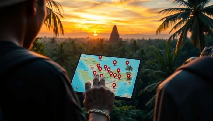
Pinpoint the fastest routes and transport choices between Belize’s main hubs—Belize City, Ambergris Caye (San Pedro), and Placencia—so you can lock an itinerary without guesswork. Open the linked interactive map, use the quick decision table, then follow the planning links to build the rest of your trip.
Decision table — pick the hub (fast reference)
Notes: times and prices are approximate and depend on season and carrier; for full transport options see our Getting Around guide.
How to use the interactive map
Open the live map to see key POIs, suggested routes, and anchor points for turn-by-turn directions. If you prefer a quick visual check, use the Google Maps Belize overview linked here: Google Maps: Belize. If you need an offline plan, drop pins for your hotel and main activities and export or screenshot your route before you travel.
- Open the map and search for your arrival hub (airport or ferry terminal).
- Drop pins for your accommodation and main activities (diving spots, ruins, beaches).
- Pick transport: flight for speed to cayes, water taxi for budget/experience, shuttle for road access.
- Save or screenshot offline; note cash-only vendors (water taxis, local shuttles).
Which hub should you choose?
Match the hub to your trip priorities:
- Ambergris Caye / San Pedro: Best for diving the Belize Barrier Reef and quick beach stays; book flights if you want speed.
- Placencia: Easier road access to southern cayes and a relaxed beach town vibe; good for families and driving itineraries.
- Belize City: Useful arrival hub and transfer point; plan onward travel the same day where possible to avoid overnight airport waits.
- Cayo / San Ignacio: Pick this for inland adventure—Maya ruins, cave tubing, and jungle lodges.
Practical travel checklist (must-do before departure)
- Download offline maps for your phone and screenshot critical routes.
- Carry small USD/BZD cash for water taxis, tips, and local vendors.
- Check domestic flight Luggage rules—small aircraft have strict limits.
- Confirm pickup times with your hotel or operator; inland roads can add 30–90 minutes in rain season.
- For diving or Blue Hole trips, see our detailed guide: Blue Hole diving guide.
Where to go next (booking & itinerary help)
When you’ve chosen a hub, use our planning pages to complete bookings and build day-by-day plans.
Short FAQ (top traveler questions)
Is Belize safe for American travelers right now?
Ambergris Caye or Caye Caulker — which to choose?

If you want a ready-made itinerary after you pick a hub, our Ultimate Planning Guide includes day-by-day templates, accommodation picks, and recommended operators to book next.
Sophie Daniels is an accomplished travel writer and expert on Belize, dedicated to sharing the beauty and culture of this Central American gem. With a passion for adventure and a deep understanding of the local landscape, she crafts insightful and engaging guides that inspire travelers to explore Belize’s vibrant ecosystems and rich heritage. Through her writing, Sophie aims to connect readers with the heart of Belize, offering practical tips and personal anecdotes that enhance their travel experiences.
The exploration of interactive maps in your blog post is particularly intriguing, especially as technology continues to shape how we travel and experience new places. As you pointed out, these digital tools are not only about guiding us from point A to point B; they enhance our understanding of the geography and culture we’re stepping into. In Belize, an area rich in biodiversity and cultural heritage, having access to an interactive map can transform a visitor’s journey into something much deeper than just sightseeing.
Your exploration of interactive maps and their significance for travelers venturing into Belize really captures the essence of modern travel planning. As someone who has relied heavily on such tools in my own travels, I can fully appreciate the balance they strike between providing information and enhancing the user experience. The way XamanekBelize makes this accessible through engaging interfaces is particularly noteworthy.
This is super helpful! I’ve always found Belize a bit daunting to navigate, especially with all the options. It’s interesting how the quickest routes can influence your overall experience. I remember choosing Ambergris Caye for a short trip, and the easy access to stunning reefs made it worth it.
Your post presents a very practical approach to navigating Belize’s main hubs, and I appreciate how the interactive map and decision tools can simplify the planning process. Belize’s diverse landscapes—from the vibrant reef around Ambergris Caye to the lush jungles near Placencia—offer various experiences that cater to different interests.
This guide provides a practical approach to navigating Belize’s hubs, emphasizing the importance of planning for a seamless travel experience. I appreciate how you’ve broken down the transport options based on the type of experience one seeks—whether it’s the stunning beaches of Ambergris Caye or the inland adventures around Belize City and Placencia.
This post about navigating the routes and transport options between Belize’s key destinations is a game-changer for anyone planning a trip! I really appreciate how you’ve broken down the transportation methods so clearly. I remember the first time I visited Ambergris Caye; deciding between the domestic flight and the water taxi was quite overwhelming, especially with the FOMO of potentially missing beautiful views across the water.
This is super helpful for planning trips in Belize! I recently visited Ambergris Caye and loved how accessible everything felt. The domestic flights are definitely the way to go if you’re short on time. I was a little hesitant at first about the water taxi, but the views were stunning and it felt like part of the adventure.
I love the breakdown of transportation options—it’s like a choose-your-own-adventure book, but instead of slaying dragons, we’re just trying to find the fastest way to a beach cocktail! I’d argue that water taxis are the ultimate thrill ride, but can we discuss the potential for hair-pulls and sunburns during a rough crossing?
This guide is incredibly helpful for anyone looking to explore the beautiful corridors of Belize! The emphasis on selecting the fastest routes and transport options really resonates with me, especially since Belize offers such a diverse range of experiences from its bustling cities to the tranquil beaches.
Navigating Belize’s main hubs can indeed be a bit overwhelming for first-time visitors, but your interactive map and quick decision table seem like game-changers! I’ve personally experienced the charm of both Ambergris Caye and Placencia, and I can attest to how different they feel. Ambergris Caye is perfect for a laid-back beach vibe with stunning snorkeling right off the coast, while Placencia offers that unique blend of coastal and inland adventures, which I found to be a delightful surprise.
I appreciate how you’ve laid out the different transport options between Belize’s main hubs. It’s so helpful to have a clear understanding of what to expect, especially when time is a factor on vacation! I found that choosing a base can really enhance the experience; for example, I chose Placencia on my last trip and loved how it blended the beach vibe with great access to inland activities like exploring the Mayan ruins and wildlife reserves.
I appreciate how you’ve laid out the options for navigating between Belize’s main hubs. Belize truly offers a unique mix of culture, adventure, and natural beauty, which makes choosing the right route and transportation all the more crucial for a fulfilling experience.
I’ve always found the transport options in Belize to be a bit of a puzzle, so I appreciate this breakdown! When I traveled there last year, I opted for the water taxi to Ambergris Caye, and the views were stunning—definitely a highlight. But I can see the appeal of Placencia for those who want to mix beach time with inland explorations. It felt like a hidden gem compared to the more touristy spots.
I appreciate how your post simplifies what can often be a daunting process when planning a trip to Belize. As someone who has recently navigated similar travel logistics, I completely understand the value of having accessible and straightforward tools, like the interactive map and quick decision table you mentioned. Being able to visualize the routes and understand the various transport methods eliminates a lot of uncertainty.
Your insights into navigating Belize’s main hubs are incredibly valuable, especially for travelers who want to maximize their experience without the hassle of complex planning. I’ve long been fascinated by how much a thoughtful itinerary can enhance not just a trip, but the exploration of culture and environment. The way you’ve highlighted the quick decision table and interactive map as tools for minimizing guesswork really underscores the importance of smart travel planning.
It’s interesting to see how travel planning is evolving with tools like interactive maps and decision tables—definitely a step away from the traditional methods. I appreciate the emphasis on narrowing down choices based on specific needs, like beach access versus road adventures. For instance, I chose Ambergris Caye last summer for its vibrant snorkeling spots, but I found Placencia surprisingly charming for a more laid-back experience with easy road access to inland attractions like the Cockscomb Basin Wildlife Sanctuary.
I appreciate the breakdown of travel options between the main hubs in Belize, but I wonder about the implications of domestic flights versus water taxis on local communities and the environment. While the speed of a flight is appealing, it feels like we might miss out on a deeper experience if we rush by water taxi. The journey along the coast can be breathtaking and might offer unique opportunities to interact with local cultures. Additionally, how do factors like weather or sea conditions influence these travel choices? It would be useful to include insights or anecdotes from travelers who have used both modes of transport, perhaps discussing what they appreciated most about their chosen method. Overall, balancing speed with the overall travel experience is crucial, especially in a place as rich in natural beauty and culture as Belize. What do you think?
This guide is incredibly helpful, especially for first-time visitors trying to navigate Belize’s beautiful landscape. The emphasis on distinguishing between Ambergris Caye and Placencia for specific experiences really clarifies things. I remember my trip there last year and how overwhelming it was to make decisions without clear guidance.